
What is the Lambeth Methodology?
The Lambeth methodology, explained simply, measures the relationship between available parking spaces and how many vehicles are occupying them. This allows planners to calculate parking stress and determine whether a parking situation is acceptable.
Policy Context and Objectives
The methodology is used to quantify parking stress within the surrounding highway network and assess the extent to which a development may affect existing conditions.
Elevated parking stress can impact highway safety, network operation, residential amenity, and access for emergency and servicing vehicles. As such, local planning authorities require a robust and transparent evidence base to support decision-making.
When is a Lambeth Survey Required?
Requirement for Survey
Parking surveys are generally required for residential development outside Controlled Parking Zones (CPZ) and may also be required for commercial schemes depending on their scale, location, and operational characteristics.
Even where on-site parking is proposed, surveys may still be necessary where demand is expected to exceed provision. In such cases, an assessment of anticipated vehicle ownership should be undertaken using local census data to estimate potential overspill parking. This should be considered alongside existing parking stress and cumulative impacts from nearby consented developments.
How the Survey Works
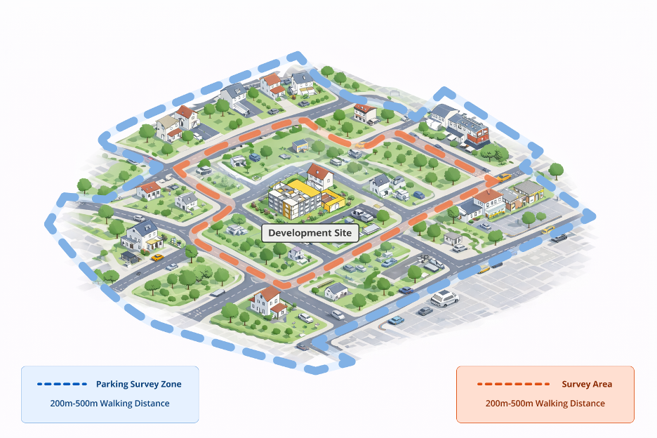
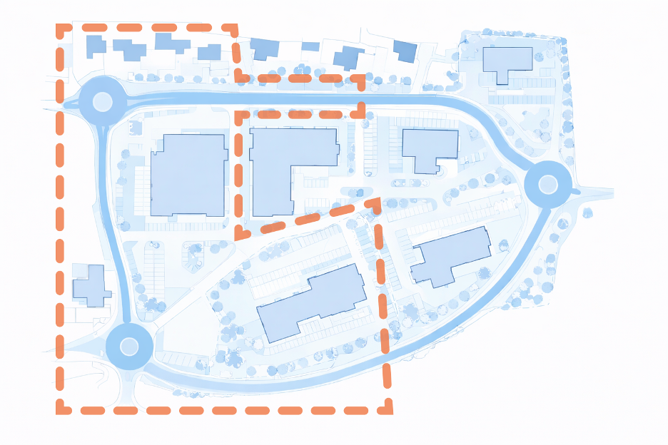
The survey area is defined by walking distance along the highway network, reflecting realistic driver behaviour when searching for parking.
Lambeth Methodology Survey Timing and Conditions:
- The survey area:
Typically 200m walking distance for residential developments and 500m for commercial. This is measured along roads, not as a straight-line radius.
- Survey timing:
Conducted overnight (00:30–05:30) when parking demand is highest, and must be carried out on two separate weekday nights. For commercial development, surveys are undertaken during operational hours, generally on an hourly beat basis unless otherwise agreed.
- Within the survey:
All roads accessible to drivers are included, ensuring realistic parking behaviour is captured.
- Within the survey area:
Exclusions may apply to private roads or unsafe locations, but justification must be provided.
All accessible streets within the survey area must be included unless there is clear justification for exclusion. Private roads, unsafe locations, or areas where parking is not feasible may be omitted, provided this is clearly documented and justified.
Parking Capacity & Stress

Parking capacity is determined by measuring available kerb space and applying a standard assumption of 5 metres per vehicle. The total usable kerb length is divided by 5 metres and rounded down to the nearest whole number.
The assessment must account for all physical and regulatory constraints, including crossovers, kerb build-outs, waiting restrictions, and other obstructions. For highway safety reasons, the first 5 metres from a junction is excluded from the calculation.
Within Controlled Parking Zones, only resident-permitted bays and shared-use bays that allow resident parking are included. Outside CPZs, all unrestricted kerb space is assessed in discrete segments between constraints.
Parking Stress Calculation
Parking stress is calculated as the ratio of parked vehicles to available capacity and is expressed as a percentage. This is assessed at both street level and across the wider survey area.
Lambeth methodology example:
- 50m of kerb = 10 parking spaces
- 10 cars parked = 100% parking stress
Stress levels may exceed 100% where parking occurs at densities greater than the standardised 5-metre assumption.
| Street Name | Kerb Length (m) | Capacity (Spaces) | Parked Vehicles | Parking Stress (%) |
| Example Street A | 120 | 24 | 22 | 92% |
| Example Street B | 80 | 16 | 14 | 88% |
| Example Street C | 60 | 12 | 12 | 100% |
| Total | 260 | 52 | 48 | 92% |
Reporting Requirements
Survey outputs must be presented in a clear and auditable format that allows independent verification by the local planning authority.
The submission should include the survey dates and times, a description of local land uses that may influence parking demand, and a clearly defined survey area with justification for any exclusions. A scaled plan should be provided showing the site location, survey boundary, and all relevant parking restrictions.
Vehicle counts must be recorded for each road and supported by detailed capacity calculations. Any unusual observations, such as suspended bays, roadworks, or temporary obstructions, should be documented as part of the survey record. Supporting photographs may be included where appropriate.
Key Components of a Compliant Submission
A Lambeth methodology parking survey must be sufficiently robust and transparent to allow the local planning authority to undertake a full and independent assessment. Submissions that are accepted without query typically demonstrate the following:
- A clearly defined survey area that reflects realistic walking routes and has been agreed or justified in line with guidance.
- Survey data collected under representative conditions, including appropriate timing and avoidance of atypical periods such as holidays or local events.
- Accurate and auditable parking capacity calculations, with all assumptions clearly stated and supported by measurement plans.
- A complete record of observed parking demand, presented at street level and supported by tabulated outputs.
- Full transparency in methodology, including justification for any exclusions and documentation of any unusual conditions observed during the survey.
- A scaled plan showing the site, survey extent, and all relevant parking restrictions, enabling verification of both capacity and coverage.
- Consideration of future parking demand, including anticipated vehicle ownership and potential overspill, informed by local data.
- Alignment with relevant planning policy, including the London Plan and local transport strategy, demonstrating how the findings have been interpreted in a policy context.
Survey Deliverables
A compliant lambeth methodology guidance report includes:
- Parking stress analysis
- Scaled mapping showing all streets within the survey area
- Vehicle counts for each section of road
- Photos of restrictions and signage
- A detailed report aligned with council transport requirements
Get Expert Support
MetroCount provides end-to-end delivery of Lambeth methodology parking surveys, combining rigorous data collection with policy-aligned analysis and reporting. Our approach ensures submissions are robust, compliant, and aligned with local authority expectations.
Got a great MetroCount story? Share it with us and let the world know the great work you're doing in your community.